Much warmer and wetter than average with an intense hot spell 25th
For much of the month July was actually very dry and also slightly cooler than average, but from the 19th the month became increasingly unsettled, wet and warm. That warmth reached its zenith on the 25th when the UK, but not Cumbria, broke its all-time highest temperature record.
The month opened with a cool north-westerly flow over the UK, but for much of the first half of the month high pressure was close by and this resulted in dry weather but with variable amounts of sunshine. The 'weather' part of the month occurred from the 19th which was generally unsettled and then saw a sudden influx of southerly air that brought a brief, but intense spell of high temperatures.
Whilst Cumbria did not see its all-time highest temperature record of 33.1°c broken, falling 1.0°c short, the UK did, but even though this was a short-lived event, night-time temperatures remained high for the last week of the month.
Up to the 18th rainfall only totalled 6.0 mm, but an inch of rain on the 19th heralded the beginning of a wet spell of weather with some fairly heavy daily falls following; some of these falls being accompanied with thunder.
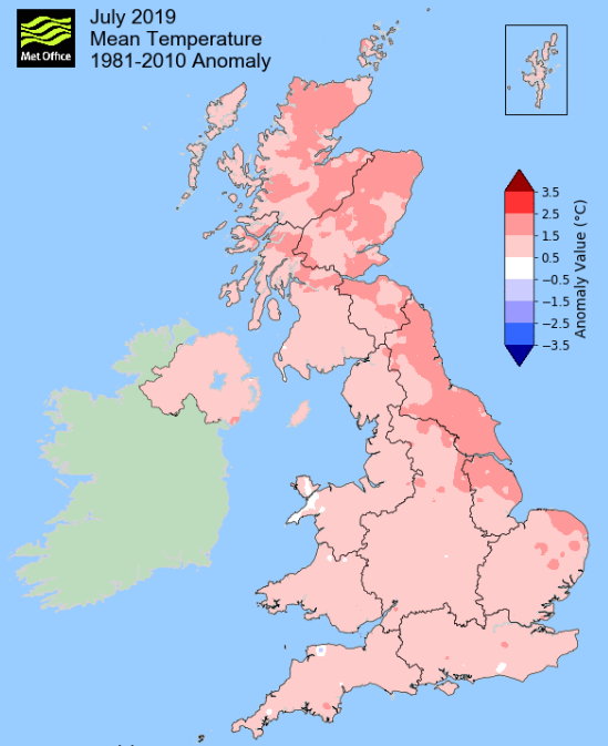
MSLP of 1014.9 Mb was +0.4 Mb above the local average for the month and overall a mean minimum of 11.63°c and a mean maximum of 20.57°c saw the temperature 1.13°c above the ten year average for this site.
It was the coldest since 2017 and of the eleven now recorded, eight have been colder and two have been warmer. The highest maximum temperature recorded was 31.7°c (25th), the lowest minimum 3.9°c (3rd).
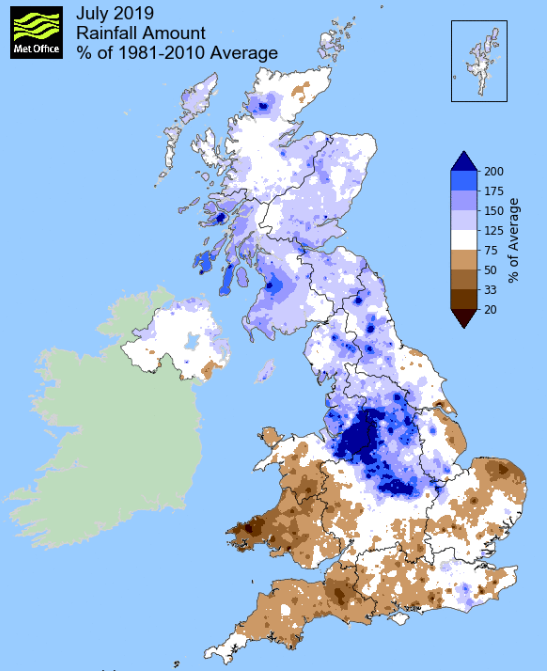
Rainfall of 120.1 mm (Crosby Ravensworth School 123.6 mm - Castlehowe Scar 168.4mm) was 119% of average for 2007-18 and made it the wettest July since 2013 - of the 13 now recorded three have been wetter and nine have been drier.
During the month, the following was recorded: thunder was heard on three days (24-25th and 30th) and an inch of rain fell on two days.
At the Met' Office site at Newton Rigg, rainfall of 116.0 mm (165%) was the wettest since 2009 and in a series back to 1900 (with records missing in 3yrs) July has been wetter in 11 years and drier in 105.
A mean temperature of 16.27°c is 1.17°c above average for the month and in a record back to 1951 (records missing in one year) July has been warmer in 8 years and colder in 59.
Locally, rainfall percentages were well above average, especially at Kirkby Thore (234%), but with percentage falls showing no particular pattern as to location.
Figures from the Environment Agency’s rainfall sites were, (figure in brackets being the monthly average for 1961-90) ‘Data kindly provided by the Hydrometry and Telemetry team of the Environment Agency (Penrith)’:
Kirkby Thore 93.4 mm (39.8 mm)
Haresceugh Castle (Kirkoswald) 108.03 mm (78.2 mm)
Brothers Water 187.84 mm (142 mm) and
Orton (Shallowford) 113.4 mm (97.9 mm [average for 1967-2018])
241.2 mm at Seathwaite Farm (Borrowdale - 204 mm [average for 1981-2010]).
General Synoptic Report for the Month
High pressure (HP) built slowly from the SW then west at the start of the month before briefly retreating on the 5th. During this time we enjoyed dry days with reasonable amounts of sun (3rd especially), but with a NW'ly flow temperatures were pegged back just below 20°c, although the 3rd did just manage to attain that mark.
The 5th was a cloudier day as low pressure (LP) to our north pushed a cold front south over the UK. However, HP to the SE of Iceland then pushed south and the 6th became a lovely sunny day, but despite that sun a NW'ly breeze kept the temperature just below 20°c.
High pressure remained over the UK 7-9th, albeit only nominally come the 9th, during which time the 7th was another fine day and did just manage 20°c before the amount of cloud increased 8th and then again 9th which saw some drizzle and the temperature back down to 16.3°c.
10-11th saw LP south of Iceland with an associated front trailing over the UK which brought a little rain and cloudier skies, albeit the afternoon of the 11th saw an improvement. This was ahead of HP moving in from the Atlantic which became dominant over the UK (centred off the northern tip of Eire). The HP would hold sway until the 17th bringing an extension to the predominantly dry month, which saw just 2.8 mm of rain up to the 16th. However, it wasn't wall to wall sun as there was always some cloud, (the 13th being the best day of the period) but it was quite pleasant with temperatures typically ranging 20-22°c.
The HP began its retreat during the 17th as LP in the Atlantic nudged east with a cold front on the 17th bringing fresher air and a slight dip in the temperature.
Up to the 18th we had hardly seen any rainfall, but this would now change with LP becoming the more dominant driver. The first LP system arrived during the 19th bringing rain later in the evening which continud overnight to give 25.4 mm credited back to the 19th.
We than sat in a brisk SW'ly flow ahead of another LP system from off the Atlantic but once again we were fortunate to see the accompanying rain (14.0 mm) fall in the evening and overnight into the 22nd.
That SW'ly became even brisker during the 22nd and saw winds gusts to 44 Mph, but now with HP virtually present over mainland Europe and LP systems in the Atlantic the winds gradually backed southerly and as a result the temperature began to rise and within the mix was thunder.
The 21.1°c of the 22nd became 27.2°c on the 23rd and whilst the 24th saw the temperature dip to just over 20°c it actually was crazily warm overnight into the 24th and created a new highest minimum temperature record for this site of 17.8°c (64°f). And that warmth was accompanied by our first thunderstorm of the month that gave 11.9 mm of rain - but now the feed of southerly air now was to reach its climax!
During the early hours of the 25th the temperature was rising quickly. Already 24.5°c at 1000 Hrs, the day just became intolerably warm, reaching 31.7°c (89.1°f - just think how warm it was and it was still shy of 90°f). This triggered a brief spell of thunder and lightning at tea-time but with just 3.9 mm of rain.
Low pressure would remain over or near to the UK for the rest of the month bringing some heavy spells of rain and whilst day-time temperatures became more tolerable either side of 20°c, the temperature at night remained oppressively high.
A warm front associated to LP south of Iceland remained virtually static north-south over the central part of the UK during the 27th and subsequently with 32.5 mm of rain it became a write off (a Saturday) and the year's wettest day.
The 30th saw another deep ALP in Biscay moving NE over the UK and this brought another spell of rain (14.4 mm) in the early hours of the 31st having been preceded by distant lightning in the afternoon of the 30th.
Rainfall totalled 120.1 mm for the month, with rain recorded on 16 days of which 11 were 'Wet days' (1.0mm +).
The Mean Temperature for the month was 16.10°c -- The Mean Max' was 20.57°c -- The Mean Min' 11.63°c.
We had 0 Air Frosts in the month (year 33) -- Grass frosts totalled 0 (year 77).
The 1 foot soil temp ranged from a low of 15.8°c on the 3rd to a high of 18.6°c on the 26th -- with a monthly mean of 16.9°c
The 1 meter soil temp ranged from a low of 13.7°c on the 1st to 5th to a high of 15.5°c on the 29th to 31st -- with a monthly mean of 14.4°c
This makes the Jan' to July period of 2019 0.38°c warmer than the average for 2009-18 and with 101.2% of average rainfall for 2007-18
JANUARY 2010
FEBRUARY 2010
MARCH 2010
APRIL 2010
MAY 2010
JUNE 2010
JULY 2010
AUGUST 2010
SEPTEMBER 2010
OCTOBER 2010
NOVEMBER 2010
DECEMBER 2010
JANUARY 2011
FEBRUARY 2011
MARCH 2011
APRIL 2011
MAY 2011
JUNE 2011
JULY 2011
AUGUST 2011
SEPTEMBER 2011
OCTOBER 2011
NOVEMBER 2011
DECEMBER 2011
JANUARY 2012
FEBRUARY 2012
MARCH 2012
APRIL 2012
MAY 2012
JUNE 2012
JULY 2012
AUGUST 2012
SEPTEMBER 2012
OCTOBER 2012
NOVEMBER 2012
DECEMBER 2012
SUMMER 2012
REVIEW OF 2012
JANUARY 2013
FEBRUARY 2013
MARCH 2013
APRIL 2013
MAY 2013
JUNE 2013
JULY 2013
AUGUST 2013
SEPTEMBER 2013
OCTOBER 2013
NOVEMBER 2013
DECEMBER 2013
REVIEW OF 2013
JANUARY 2014
FEBRUARY 2014
MARCH 2014
APRIL 2014
MAY 2014
JUNE 2014
JULY 2014
AUGUST 2014
SEPTEMBER 2014
OCTOBER 2014
NOVEMBER 2014
DECEMBER 2014
WINTER 2014
REVIEW OF 2014
JANUARY 2015
FEBRUARY 2015
MARCH 2015
APRIL 2015
MAY 2015
JUNE 2015
JULY 2015
AUGUST 2015
SEPTEMBER 2015
OCTOBER 2015
NOVEMBER 2015
DECEMBER 2015
REVIEW OF 2015
JANUARY 2016
FEBRUARY 2016
MARCH 2016
APRIL 2016
MAY 2016
JUNE 2016
JULY 2016
AUGUST 2016
SEPTEMBER 2016
OCTOBER 2016
NOVEMBER 2016
DECEMBER 2016
REVIEW OF 2016
JANUARY 2017
FEBRUARY 2017
MARCH 2017
APRIL 2017
MAY 2017
JUNE 2017
JULY 2017
AUGUST 2017
SEPTEMBER 2017
OCTOBER 2017
NOVEMBER 2017
DECEMBER 2017
REVIEW OF 2017
JANUARY 2018
FEBRUARY 2018
MARCH 2018
APRIL 2018
MAY 2018
JUNE 2018
JULY 2018
AUGUST 2018
SEPTEMBER 2018
OCTOBER 2018
NOVEMBER 2018
DECEMBER 2018
REVIEW OF 2018
JANUARY 2019
FEBRUARY 2019
MARCH 2019
APRIL 2019
MAY 2019
JUNE 2019
OTHER ARTICLES
The Oldest Inhabitant
An Inch Of Scotch Mist
But it's meant to be Summer (Summer 2017)
© Darren Rogers 2010-19
Want to comment on this site? email